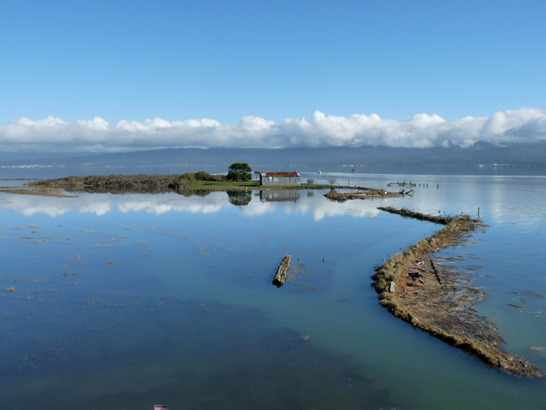
Tuluwat, King Tide 8.94’ 2010
The Humboldt Bay Sea Level Rise Adaptation Planning Project (Project) is a multi-phased regional collaboration funded by the California State Coastal Conservancy. Its purpose is to inform the public and local agencies of the risk that sea level rise poses to the communities and environment on Humboldt Bay and identify adaptation strategies and options to protect critical regional assets. Thus far, the Project has consisted of two Phases:
- 2010-2013, Phase I: Humboldt Bay Shoreline Inventory, Mapping and Sea Level Rise Vulnerability Assessment.
- 2013-2015, Phase II: Humboldt Bay Sea Level Rise Inundation Vulnerability Modeling, Mapping and Adaptation Planning
The Humboldt Bay Sea Level Rise Adaptation Plan explores the: how, where, when, what, and who of sea level rise and adaptation planning on Humboldt Bay. The report also presents in-depth adaptation planning case studies for two critical regional assets that are at risk from sea level rise: agricultural lands and uses and the Highway 101 corridor.
The APWG is now composed of 22 regional stakeholders with land use, land management, resources management responsibilities, or management advisory roles on lands adjacent to Humboldt Bay that are vulnerable to sea level rise impacts:
- Bureau of Land Management
- California Coastal Conservancy
- California Coastal Commission, North Coast District
- California Department of Fish and Wildlife
- California Department of Transportation, District 1
- California Sea Grant Extension
- City of Arcata: Planning, Public Works, and Environmental Services Departments
- City of Eureka: Planning and Public Works Departments
- Coastal Ecosystem Institute of Northern California
- Humboldt Bay Harbor, Recreation, and Conservation District
- Humboldt Bay National Wildlife Refuge
- Humboldt County Farm Bureau
- Humboldt County: Public Works and Planning and Building Departments
- Humboldt County Resources Conservation District
- National Resources Conservation Service
- Northcoast Regional Land Trust
- Northern Hydrology and Engineering
- Pacific Gas & Electric
- Trinity Associates
- U.C. Agricultural Extension: Humboldt County
- U.S. Fish and Wildlife Service
- Wiyot Tribe
Adaptation Planning Working Group: 2015 Meeting Schedule
- April 29 th
- June 24 th
- August 26 th
- October 28 th
- December 30 th
Download Project Documents, and GIS Databases:
- Phase I:
-
Phase II:
- Humboldt Bay Sea Level Rise Hydrodynamic Modeling and Inundation Vulnerability Mapping
- Humboldt Bay Sea Level Rise Adaptation Planning Project Phase II Report
- Sea Level Rise to Outpace Rising Waters Building Resilient Infrastructure - Seemann
Download Adaptation Planning Working Group Meeting Presentations
APWG Agenda 02-27-2013APWG Agenda 04-24-2013
APWG Agenda 07-16-2013
APWG Agenda 08-28-2013
APWG Agenda 10-30-2013
APWG Public Meeting 11-12-2013
APWG Agenda 02-26-2014
APWG Agenda 04-30-2014
APWG Agenda 06-25-2014
APWG Agenda 08-27-2014
APWG Agenda 10-29-2014
APWG Public Meeting 11-17-2014
APWG Agenda 01-07-2015
APWG Agenda 04-29-2015
CONTACTS
Aldaron LairdAdaptation Planner
Humboldt Bay Sea Level Rise Adaptation Planning Project
Trinity Associates
hbslrplanner@gmail.com
707.845.6877
Jeff Anderson
Northern Hydrology & Engineering
jeff@northernhydrology.com
707.839.2195
Rob Holmlund
Director of Development
Humboldt Bay Harbor, Recreation, and Conservation District
rholmlund@humboldtbay.org
707.443.0801 x122
Hank Seemann
Deputy Director
Environmental Services, Humboldt County Public Works
hseemann@co.humboldt.ca.us
707.445.7741
Jill Demers
Coastal Ecosystems Institute of Northern California
jill@coastalecosystemsinstitute.org
707.667.6163
Joel Gerwein
Project Manager
State Coastal Conservancy
Joel.Gerwein@scc.ga.gov
510.286.4170


